Geology
Mount Evans was carved from the rock of the Mount Evans Batholith,
 formed by an intrusion of magma into the earth's crust about 1.4 billion years ago (in the Mesoproterozoic Era of the Precambrian Eon).
The mountain sits on the southern margin of the Colorado Mineral Belt. Mount Evans is the highest peak in the Mount Evans Wilderness in
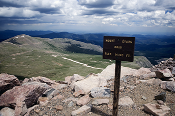
the Front Range of the Rocky Mountains of North America. The prominent 14,271-foot (4,350 m) fourteener is located 13.4 miles (21.6 km)
southwest by south of Idaho Springs in Clear Creek County, Colorado, United States. The peak is one of the characteristic Front Range
peaks, dominating the western skyline of the Great Plains along with Pikes Peak, Longs Peak, and nearby Mount Bierstadt. Mount Evans
can be seen from over 100 miles (160 km) to the east and many miles in other directions.
formed by an intrusion of magma into the earth's crust about 1.4 billion years ago (in the Mesoproterozoic Era of the Precambrian Eon).
The mountain sits on the southern margin of the Colorado Mineral Belt. Mount Evans is the highest peak in the Mount Evans Wilderness in
the Front Range of the Rocky Mountains of North America. The prominent 14,271-foot (4,350 m) fourteener is located 13.4 miles (21.6 km)
southwest by south of Idaho Springs in Clear Creek County, Colorado, United States. The peak is one of the characteristic Front Range
peaks, dominating the western skyline of the Great Plains along with Pikes Peak, Longs Peak, and nearby Mount Bierstadt. Mount Evans
can be seen from over 100 miles (160 km) to the east and many miles in other directions.
History
 Mount Evans is a prominent mountain in Colorado, United States. It was named after John Evans,
the second territorial governor of Colorado in 1895. The mountain was initially named after
Rosalie by Albert Bierstadt, who became the first known person to summit the mountain in 1863.
The Mount Evans Scenic Byway is part of the Denver Mountain Parks system and was constructed
to allow Denverites to explore the mountains. The road opened to the public in June 1931 and
at that time it was the highest road in the world. Today it is the highest road in North America.
Mount Evans is a prominent mountain in Colorado, United States. It was named after John Evans,
the second territorial governor of Colorado in 1895. The mountain was initially named after
Rosalie by Albert Bierstadt, who became the first known person to summit the mountain in 1863.
The Mount Evans Scenic Byway is part of the Denver Mountain Parks system and was constructed
to allow Denverites to explore the mountains. The road opened to the public in June 1931 and
at that time it was the highest road in the world. Today it is the highest road in North America.
``
Visiting
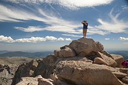
Mount Evans is a popular tourist destination in
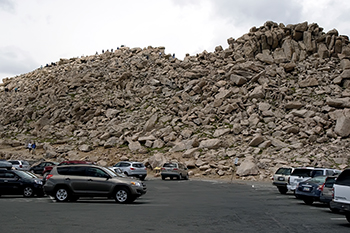
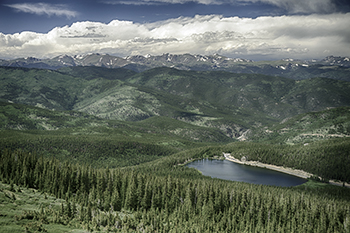
Colorado. The Mount Evans Scenic Byway is the highest paved road in North America and offers
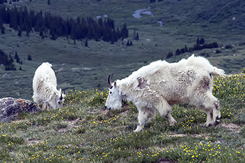
breathtaking views of alpine lakes, massive granite walls, and strands of twisted, ancient
bristlecone pine. Along the way, you may see marmots, mountain goats, and bighorn sheep
that call the mountain home.
 The byway starts at Echo Lake and climbs 14 miles to the summit. In just three miles, the
road breaks above timberline. An excellent stop here is at the Walter Pesman Alpine Garden,
where you can view
The byway starts at Echo Lake and climbs 14 miles to the summit. In just three miles, the
road breaks above timberline. An excellent stop here is at the Walter Pesman Alpine Garden,
where you can view
 1,700-year-old Bristlecone pines. In summer, be sure to stop at the Echo Lake Lodge, an
authentic 1926 log building with a charming four-sided stone fireplace. The lodge has a restaurant,
bar, and gift shop and is known for their pan-fried trout. Please note that the Mount Evans
Highway (Colorado Hwy. 5, from Echo Lake to the summit) will require timed-entry reservations
1,700-year-old Bristlecone pines. In summer, be sure to stop at the Echo Lake Lodge, an
authentic 1926 log building with a charming four-sided stone fireplace. The lodge has a restaurant,
bar, and gift shop and is known for their pan-fried trout. Please note that the Mount Evans
Highway (Colorado Hwy. 5, from Echo Lake to the summit) will require timed-entry reservations
 during the summer available from Recreation.gov. There is also a per-vehicle amenity recreation fee to
enter Summit Lake Park, as well as to park at Mount Goliath Natural Area and the Summit of Mount Evans Interpretive site.
during the summer available from Recreation.gov. There is also a per-vehicle amenity recreation fee to
enter Summit Lake Park, as well as to park at Mount Goliath Natural Area and the Summit of Mount Evans Interpretive site.
Driving to the summit of Mount Evans can be a heart-stopping experience due to the narrow
road and sharp drop-offs. The road is not as wide as Pikes Peak and sometimes double yellow
lines are painted in the middle of a narrow one and a half-lane road. Because of the narrow
road, room for error is not an option. Mainly, because in some segments not even an inch of
shoulder exists where the edge pavement meets a sharp drop off. You are not only responsible
for your driving but, at the same time, need to anticipate what other drivers are doing. Some
people drive their vehicles over their lane and into yours. Another potential danger is altitude
sickness. Coming directly from sea level, you would most likely get dizzy, be lightheaded,
develop a headache and some nausea and suffer from shallow breathing, increased heartrate
and sweaty palms. Trying to drive to Mount Evans under those circumstances would be very dangerous.
Structures
There are three significant structures
at the summit of Mount Evans: the ruins of the Crest House, the High Altitude Lab,
and the Meyer-Womble Observatory. The Crest House was first opened to the public in
1942, serving as a restaurant and souvenir shop. In 1979, the Crest House burned in
a propane fire.
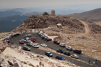 The Meyer-Womble Observatory is an astronomical observatory owned and operated by
the University of Denver. It is located near the summit of Mount Evans in the Arapaho
National Forest approximately 60 kilometers (37 mi) west of Denver, Colorado (USA).
At an elevation of 4,326 meters (14,193 ft), it is the third-highest optical/infrared
observatory in the world. The High Altitude Lab is a wooden double A-frame building
that was constructed by the University of Denver in 1935 to support cosmic ray research.
In 1948, it was brought under the banner of the Inter-University High Altitude Labs (IUHAL),
a coalition between several universities for the study of cosmic rays. Seven universities
including the University of Denver, Cornell, MIT, and Syracuse University collaborated under IUHAL.
The Meyer-Womble Observatory is an astronomical observatory owned and operated by
the University of Denver. It is located near the summit of Mount Evans in the Arapaho
National Forest approximately 60 kilometers (37 mi) west of Denver, Colorado (USA).
At an elevation of 4,326 meters (14,193 ft), it is the third-highest optical/infrared
observatory in the world. The High Altitude Lab is a wooden double A-frame building
that was constructed by the University of Denver in 1935 to support cosmic ray research.
In 1948, it was brought under the banner of the Inter-University High Altitude Labs (IUHAL),
a coalition between several universities for the study of cosmic rays. Seven universities
including the University of Denver, Cornell, MIT, and Syracuse University collaborated under IUHAL.
 formed by an intrusion of magma into the earth's crust about 1.4 billion years ago (in the Mesoproterozoic Era of the Precambrian Eon).
The mountain sits on the southern margin of the Colorado Mineral Belt. Mount Evans is the highest peak in the Mount Evans Wilderness in
the Front Range of the Rocky Mountains of North America. The prominent 14,271-foot (4,350 m) fourteener is located 13.4 miles (21.6 km)
southwest by south of Idaho Springs in Clear Creek County, Colorado, United States. The peak is one of the characteristic Front Range
peaks, dominating the western skyline of the Great Plains along with Pikes Peak, Longs Peak, and nearby Mount Bierstadt. Mount Evans
can be seen from over 100 miles (160 km) to the east and many miles in other directions.
formed by an intrusion of magma into the earth's crust about 1.4 billion years ago (in the Mesoproterozoic Era of the Precambrian Eon).
The mountain sits on the southern margin of the Colorado Mineral Belt. Mount Evans is the highest peak in the Mount Evans Wilderness in
the Front Range of the Rocky Mountains of North America. The prominent 14,271-foot (4,350 m) fourteener is located 13.4 miles (21.6 km)
southwest by south of Idaho Springs in Clear Creek County, Colorado, United States. The peak is one of the characteristic Front Range
peaks, dominating the western skyline of the Great Plains along with Pikes Peak, Longs Peak, and nearby Mount Bierstadt. Mount Evans
can be seen from over 100 miles (160 km) to the east and many miles in other directions. Mount Evans is a prominent mountain in Colorado, United States. It was named after John Evans,
the second territorial governor of Colorado in 1895. The mountain was initially named after
Rosalie by Albert Bierstadt, who became the first known person to summit the mountain in 1863.
The Mount Evans Scenic Byway is part of the Denver Mountain Parks system and was constructed
to allow Denverites to explore the mountains. The road opened to the public in June 1931 and
at that time it was the highest road in the world. Today it is the highest road in North America.
Mount Evans is a prominent mountain in Colorado, United States. It was named after John Evans,
the second territorial governor of Colorado in 1895. The mountain was initially named after
Rosalie by Albert Bierstadt, who became the first known person to summit the mountain in 1863.
The Mount Evans Scenic Byway is part of the Denver Mountain Parks system and was constructed
to allow Denverites to explore the mountains. The road opened to the public in June 1931 and
at that time it was the highest road in the world. Today it is the highest road in North America. The byway starts at Echo Lake and climbs 14 miles to the summit. In just three miles, the
road breaks above timberline. An excellent stop here is at the Walter Pesman Alpine Garden,
where you can view
The byway starts at Echo Lake and climbs 14 miles to the summit. In just three miles, the
road breaks above timberline. An excellent stop here is at the Walter Pesman Alpine Garden,
where you can view
 1,700-year-old Bristlecone pines. In summer, be sure to stop at the Echo Lake Lodge, an
authentic 1926 log building with a charming four-sided stone fireplace. The lodge has a restaurant,
bar, and gift shop and is known for their pan-fried trout. Please note that the Mount Evans
Highway (Colorado Hwy. 5, from Echo Lake to the summit) will require timed-entry reservations
1,700-year-old Bristlecone pines. In summer, be sure to stop at the Echo Lake Lodge, an
authentic 1926 log building with a charming four-sided stone fireplace. The lodge has a restaurant,
bar, and gift shop and is known for their pan-fried trout. Please note that the Mount Evans
Highway (Colorado Hwy. 5, from Echo Lake to the summit) will require timed-entry reservations
 during the summer available from Recreation.gov. There is also a per-vehicle amenity recreation fee to
enter Summit Lake Park, as well as to park at Mount Goliath Natural Area and the Summit of Mount Evans Interpretive site.
during the summer available from Recreation.gov. There is also a per-vehicle amenity recreation fee to
enter Summit Lake Park, as well as to park at Mount Goliath Natural Area and the Summit of Mount Evans Interpretive site. The Meyer-Womble Observatory is an astronomical observatory owned and operated by
the University of Denver. It is located near the summit of Mount Evans in the Arapaho
National Forest approximately 60 kilometers (37 mi) west of Denver, Colorado (USA).
At an elevation of 4,326 meters (14,193 ft), it is the third-highest optical/infrared
observatory in the world. The High Altitude Lab is a wooden double A-frame building
that was constructed by the University of Denver in 1935 to support cosmic ray research.
In 1948, it was brought under the banner of the Inter-University High Altitude Labs (IUHAL),
a coalition between several universities for the study of cosmic rays. Seven universities
including the University of Denver, Cornell, MIT, and Syracuse University collaborated under IUHAL.
The Meyer-Womble Observatory is an astronomical observatory owned and operated by
the University of Denver. It is located near the summit of Mount Evans in the Arapaho
National Forest approximately 60 kilometers (37 mi) west of Denver, Colorado (USA).
At an elevation of 4,326 meters (14,193 ft), it is the third-highest optical/infrared
observatory in the world. The High Altitude Lab is a wooden double A-frame building
that was constructed by the University of Denver in 1935 to support cosmic ray research.
In 1948, it was brought under the banner of the Inter-University High Altitude Labs (IUHAL),
a coalition between several universities for the study of cosmic rays. Seven universities
including the University of Denver, Cornell, MIT, and Syracuse University collaborated under IUHAL.